“Story Maps provides a smoother entry point for instructors and
students to apply spatial thinking to their disciplines”
The entire point of teaching is making your material accessible to as many students as possible. Accommodation for certain students, simplification of material to convey the lesson in an easily digestible fashion, so on and so forth. Spatial thinking is understanding the physical world around you, or being able to envision the size of locations and objects. This is a difficult skill for some, as some people have issues with imagining physical things in their heads, so with the help of a tool like story maps we allow these students (and everyone else) a chance to more easily get into the mindset needed for thinking about History.
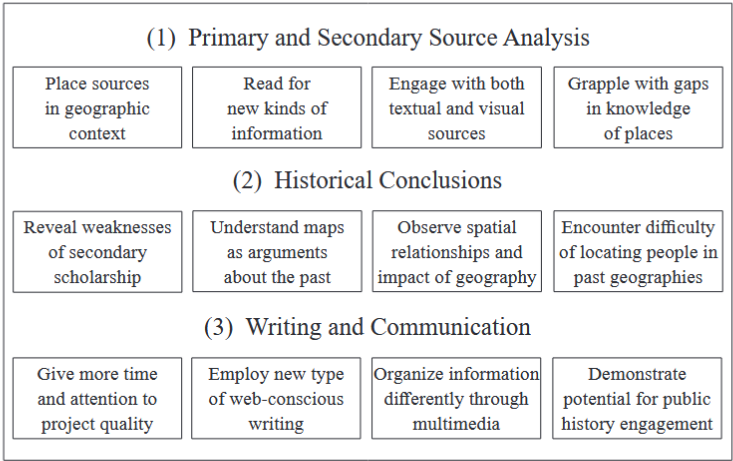
The headings represent pillars of historical research and writing, followed by the
different lessons observed across the courses discussed here.
“It was clear from the completed story map that the project
impacted how these students approached historical research and
writing…”
Having assigned groups to create story maps together, the article shows the amazing results. It allowed for them to further visualize the concepts discussed in class, and also gave them tools to use in other classes. The impact of story maps and spatial thinking was noticed by everyone who had participated in the project. Throughout the article various professors asked for different criteria in their project guidelines, showcasing the multifaceted uses of story maps. The long term scale of these projects also manages to draw in the attention of students over the course of the semester or however long the project was assigned, leading me to believe that it does a good job in keeping the students engaged.
“Even when sources clearly stated addresses, they were often still
difficult to pin exact locations on the map.”
As for issues regarding this method, the article does a fine enough job showcasing some. Due to the nature of maps it is sometimes hard to pinpoint exact locations. Some people have trouble reading maps, as well as the fact that due to maps coming in so many levels of detail it can be hard to figure out what map best works for the students. But this issue can be somewhat of a learning experience as well. In this day and age our maps are entirely digital and on our phones, but even with all of the internets power we still sometimes manage to get lost. (Trust me, I’ve ordered enough DoorDash to know that some people can’t read maps.) So researching various maps can lead students to carry these tools not only to other classes, but also to the outside world to assist in spatial thinking and map reading.